GPS ACTIVE โ€” LOGGING ROAD CONDITIONS

Map Road Conditions.
Your Server. Your Data.

A professional GPS and sensor logger for iPhone. Record road quality, detect driving events, and publish telemetry to our secure Canadian AWS broker (ca-central-1, 90-day retention, delete-on-demand). Bring-your-own-broker support is coming in a future release.

iOS 16.0+ ยท CarPlay ยท Background logging ยท Free during 1.2.x beta  ยท  Join the TestFlight beta for early access to 1.2.1 + 1.3.0

Map Telemetry navigation view โ€” turn-by-turn directions over OpenStreetMap with multiple stops, route polyline, and live telemetry stats below the map.
Turn-by-turn nav with stops + live telemetry
Map Telemetry traffic camera overlay โ€” green camera icons along the highway with a live camera feed sheet showing the road below.
Traffic cameras with live feed
Map Telemetry landscape view โ€” turn-by-turn route on the left, dashboard chips (speed, altitude, GPS accuracy, events, trail) on the right.
Landscape โ€” nav + dashboard side by side
๐Ÿ”’

Transparent by design

Telemetry is published to a secure MQTT service in Canada (AWS IoT, ca-central-1). Data is retained for 90 days and automatically deleted after. You can request immediate deletion of all your data from the app at any time โ€” GDPR compliant. No data is sold or shared with third parties. See the Privacy Policy for full details.

Everything you need to map and log road data

Built for field professionals, infrastructure teams, and anyone who needs ground-truth road condition data with full control over where it goes.

๐Ÿ“ก
Background Telemetry
GPS, accelerometer, gyroscope, barometer, and noise published over MQTT โ€” even with the screen off. HAE, CE, and LE included in every GPS payload.
๐Ÿ›ฃ๏ธ
Road Mapping
Record per-point road grade (slope %) and roughness (m/sยฒ) at maximum sensor rate. Review as colour-coded 3D routes โ€” toggle between grade and roughness overlays.
โš ๏ธ
Road Event Detection
Automatic detection of potholes, hard braking, hard acceleration, and swerve events using the device IMU. Events are timestamped and geotagged.
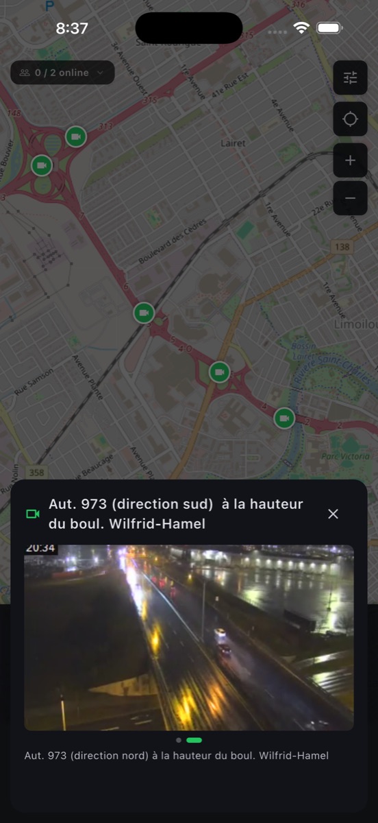
๐Ÿšฆ
Road Alerts
Real-time 511 road conditions for ON, QC, BC, and AB overlaid on the map. National NAAD emergency alerts included.
๐Ÿš—
CarPlay
Navigation steps on your infotainment display with live distance countdown. Tap "All Steps" to see the full route list without touching your phone.
๐Ÿ—บ๏ธ
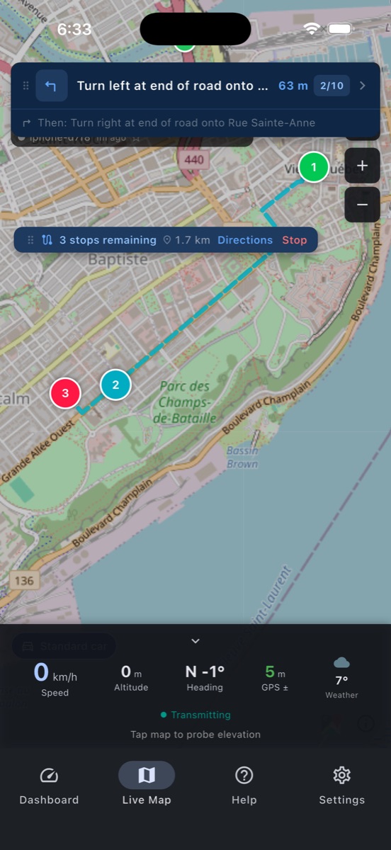
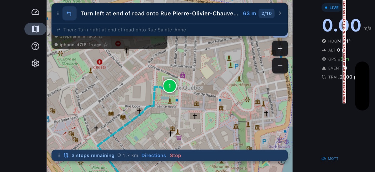
Turn-by-Turn Navigation
Voice-guided navigation with speed-aware announcements. Long-press any road to preview an alternate via-road route and see the time/distance delta before committing.
๐Ÿš›
Vehicle Profiles
Set your vehicle's height, width, and weight to automatically route around low bridges, narrow passages, and weight-restricted roads. Save multiple vehicles and switch on the fly.
๐ŸŒ
2D & 3D Maps
MapLibre 2D and Apple Maps 3D with live position, heading-follow, and terrain. Long-press for Go Here, Add a Stop, or Report an Event.
๐ŸŽฏ
Precision GPS
HAE, circular error (CE), and linear error (LE) published in every GPS payload for high-accuracy mapping workflows.
๐Ÿ“ค
Export Anywhere
Share sessions and mapped routes as GPX, CSV, GeoJSON, or KML via AirDrop, Mail, or Files. Import GPX routes from AirDrop or Files.
GPX CSV GeoJSON KML MQTT AWS IoT

Operator dashboard included

A browser-based command centre at monitor.mapgeometrics.com. See every device on a live map โ€” no install required.

๐Ÿ–ฅ๏ธ
Live Map
All devices on a single MapLibre GL map with animated markers, breadcrumb trails, and road event overlays. Works on desktop and tablet.
โฎ๏ธ
Historical Playback
Replay any device's track from the last 90 days. Scrub through the timeline with adjustable speed (1ร—โ€“10ร—).
๐Ÿ“‹
Route Dispatch
Build multi-stop routes and send them to drivers. Track acceptance, live progress, and turn-by-turn status in real time.

What's shipped, version by version

Every feature lands in a versioned release. 1.2.0 is live on the App Store; 1.2.1 (build 125) is in external TestFlight beta โ€” apply for the public link below; 1.3.0 is the next planned release and will introduce paid tiers.

Looking for the full per-version history? See the changelog.

v1.0.0 App Store
  • Background GPS + IMU telemetry โ†’ our secure Canadian AWS IoT broker (custom-broker support is on the 1.3.x roadmap)
  • Road mapping โ€” per-point grade (slope %) and roughness (m/sยฒ) at maximum sensor rate; 3D-rendered route, export, upstream upload
  • Apple Maps 3D on iOS with gyroscope-driven camera pitch
  • Road Alerts โ€” 511 (ON / QC / BC / AB) + NAAD national emergency feed overlaid on the map
  • Dispatch routes โ€” receive a route, accept or decline with countdown, multi-stop optimization
  • CarPlay navigation directions; live turn-by-turn with auto-advance and off-route detection
  • Long-press action sheet โ€” Go here, Add a Stop, Report an Event
  • Map events (road work, accidents, hazards) with MQTT pub/sub
  • Adaptive speed unit (m/s below 1 km/h, km/h above); first-launch data consent + power optimisation
  • 1.1.x added voice-guided navigation and GDPR data deletion
v1.2.0 App Store
  • First-launch onboarding wizard
  • Settings moved to bottom navigation
  • Light / dark / system theme + adaptive bottom sheets
  • Multi-direction traffic cameras + Quebec MTQ video playback
  • Tappable turn banner + visible routing failure feedback
  • Mapbox Directions as primary router, OSRM as fallback
  • Default to flutter_map + 7-tap version unlock for developer tools
v1.2.1 TestFlight
  • Apple Maps photoreal Flyover โ€” 3D buildings + terrain via MKMapConfiguration.elevationStyle (iOS 16+); Standard / Satellite / Hybrid picker with separate Flyover toggle
  • Saved Places โ€” Home / Work / favorites / recent searches in the search bar; tap to navigate, long-press to save / set / remove
  • Saved Routes โ€” save the active dispatch route to the device; recall later from Map Tools โ†’ Saved Routes
  • Auto theme by daylight โ€” switch to dark at sunset, light at sunrise (Settings โ†’ Appearance โ†’ "Daylight"). Pure-Dart sunrise/sunset, no external API
  • "Go here" preview โ€” driving distance, heading needle (cardinal), and ETA shown before you commit; routed via Mapbox/OSRM, instant great-circle estimate while routing loads
  • Lane guidance + exit numbers in the turn banner (Mapbox routes)
  • Route elevation profile โ€” heading + speed-limit ETA-from-cursor + actual routed distance (no more mismatch with the Directions sheet); on-map navigation arrow rotates with the cursor; map stays interactive while sheet is open
  • Trip summary at the end of a road-mapping session โ€” distance, duration, avg/max speed, max grade, climb, events captured
  • Adjustable road-map color thresholds โ€” Grade max ยฑ% and Roughness max RMS sliders so urban data isn't all-green
  • Search ranking โ€” typing "downtown" no longer floods the list with far-away matches before nearby ones (viewbox proximity bias)
  • Route banner shows remaining distance to destination, with optional speed-limit ETA stacked when it differs from traffic ETA
  • Picking a destination centers the map and drops a deep-purple pin; map stays pannable while the action sheet is open
  • International traffic feeds โ€” TfL London, France, NSW + Victoria, NZ NZTA, Finland Fintraffic, Norway, Netherlands, UK National Highways (some need API keys); DATEX II XML parser shared across European feeds
  • Flashing speed-limit alert (configurable threshold); compass with heading needle; coordinate search (decimal, hemisphere, DMS)
  • In-app developer console captures all logs; share as file via AirDrop / Files
  • Per-feed circuit breaker โ€” broken upstreams skip the polling budget; Settings dialogs include step-by-step instructions + portal links for API keys
  • Fixes: Apple 3D zoom preserved across tilts, Hybrid no longer flashes satellite, multi-stop optimizer respects input order, battery-low tap-to-Eco actually switches preset
v1.3.0 Planned ยท Paid
See the roadmap โ€” first release with subscription tiers (Free / Standard / Fleet).

v1.3.0 โ€” coming soon

The next release introduces the in-vehicle experience, marine navigation, and offline operation. v1.3.0 is the first paid release โ€” Free tier remains usable; Standard and Fleet subscriptions unlock the items below. Early-access TestFlight users keep current Standard features free for life.

๐Ÿš—
CarPlay full navigation
CPMapTemplate-based turn-by-turn directly on the infotainment display โ€” full route preview, lane guidance, voice prompts.
๐Ÿค–
Android Auto
Same nav surface on Android Auto-equipped vehicles โ€” feature parity with CarPlay where the platform allows.
โŒš
Apple Watch companion
Glanceable turn-by-turn directions on the wrist plus haptic alerts when the speed-limit threshold is exceeded.
๐Ÿ“ฅ
Offline map tiles
Download bounded regions on Wi-Fi and use them anywhere โ€” rural roads, tunnels, ferries, international roaming.
โ›ต
Marine navigation
OpenSeaMap overlay with depth contours and tide overlays. New boat vehicle profile (powerboat / sailboat) with draft + mast-height constraints.
๐Ÿš›
Truck-profile routing
Vehicle dimensions (height, weight, width, length) honoured by every routing call โ€” automatic re-route around restrictions.
๐Ÿšง
Route exclusions
Per-trip toggles to avoid tolls, motorways, or ferries via Mapbox's exclude parameter.
๐ŸŒฑ
Eco / fuel-efficient routing
Alternative route option optimised for fuel economy and emissions, often within a few percent of the fastest time.
๐ŸŒ
Global traffic providers
Mapbox Traffic, HERE, and TomTom as commercial fallbacks where free open-data feeds don't reach.
๐Ÿ’ณ
Subscription tiers
Free / Standard / Fleet plans via RevenueCat + StoreKit 2. See pricing.

Simple plans, no surprises

Free during the 1.2.x beta. Paid plans launch with v1.3.0 โ€” early-access TestFlight users keep their current Standard-tier features free for life.

Free
GPS recording, road event detection, 511 & NAAD alerts, elevation chart, GPX/CSV/KML/GeoJSON export.
Standard ยท $4.99/mo
Everything in Free + MQTT telemetry, multi-device presence, turn-by-turn navigation, CarPlay, road mapping with 3D overlay, stealth mode.
Fleet ยท $14.99/mo
Everything in Standard + unlimited devices, operator dashboard, route dispatch, historical playback, analytics.

Bring your own server

Map Telemetry uses standard MQTT over TLS. Point it at any broker โ€” AWS IoT, Mosquitto, HiveMQ, or your own. Devices self-provision on first launch with AWS IoT fleet provisioning. No registration, no cloud dependency on our end.

โ˜๏ธ
AWS IoT Ready
Devices self-register with AWS IoT on first launch using a claim certificate. No manual device configuration required.
๐Ÿ”
mTLS Security
Mutual TLS authentication. Private keys stored in the iOS Keychain โ€” never transmitted or backed up.